Wayfinding: The process or activity of ascertaining one’s position and following a route.
Indoor Mapping: Indoor mapping visualizes an indoor floor plan and spatial data on a digital 2D or 3D map. The indoor map displays layers of content such as labels, beacons, icons, events, tours, floors, floor connections, and pathways. There are additional layers that can be added beyond those listed above.
Indoor Positioning: The process of determining the location of a mobile device, usually a smartphone or smartwatch, by using internal and external sensors, receivers, and transmitters, inside of a building. Accuracy for an indoor positioning system can range between 2 to 20 meters, but should usually be described as a statistic rather than a fixed number. Only available through an app, browsers (Google Chrome/Safari/Edge) do not currently support this technology.
Indoor Positioning System (IPS): A network of devices used to locate people or objects where GPS and other satellite technologies lack precision or fail entirely, such as inside multistory buildings, airports, alleys, parking garages, and underground locations.
Global Positioning System (GPS): An accurate worldwide navigational and surveying facility based on the reception of signals from an array of orbiting satellites.
Bluetooth Low Energy (BLE): A short-range wireless technology standard that is used for exchanging data between fixed and mobile devices over short distances using UHF radio waves in the ISM bands, from 2.402 GHz to 2.48 GHz, and building personal area networks (PANs).
BLE IPS: uses a network of tiny transmitters called beacons, strategically located within a space. One of the RF-based technologies that has been utilizing Received Signal Strength Indicators (RSSI) in indoor position location systems (IPS). As part of the broadcast message decoding, the BLE software stacks return the (RSSI) value. This value can be used to approximate distance and when measurements from multiple devices are combined with an accuracy of 2-4 meters.
Wi-Fi Indoor Positioning: Rather than using Bluetooth, it is possible to use Wi-Fi access points for indoor positioning. This method is not as accurate as Bluetooth and since Apple prohibits developers from obtaining the signal strength of Wi-Fi access points.
Indoor Routing Algorithm: A series of computer operations to generate the most appropriate route from one indoor position to another indoor position. A good indoor routing algorithm accommodates accessibility requirements, factors in user’s security access, in addition to the physical layout of the building.
Beacon: A beacon, in its most general usage, is a piece of hardware that transmits a signal enabling Cartogram to determine the indoor location of users. Cartogram currently uses Bluetooth beacons have a battery life of 3 – 4 years. However, it is likely that another type of beacon technology (not currently available) called UWB or ultra-wideband, will dominate the market in the next 5-10 years due to higher accuracy. UWB is not currently used because there is no support for current-generation smartphones. The word “beacon” should be distinguished from iBeacon. A beacon is not an iBeacon. iBeacon is a specific configuration of a Bluetooth beacon. Eddystone is like iBeacon, except better.
Indoor Location Sharing: The ability to share an indoor location with another person or system to improve communication. Describing a physical location indoors is very difficult to do with text, such as in a text message. A web link provides the ability for people to share indoor locations, which can be opened in any browser. The process for indoor location sharing can be either automatic or manual. A manual system, where the user explicitly selects a building, a floor of a building, and a point (latitude and longitude) inside that floor. An automatic system, automatically determines a user’s indoor position, using beacons and indoor positioning.
Tiles (also called Map Tiles or Raster Tiles): Due to the large image sizes of indoor maps, which often can be upwards of 30,000 pixels in a single dimension, tiles are often generated in order to make sure that the map looks crisp at any zoom level. Map images with height and width of less than 2000 pixels do not need to be tiled.
GeoJSON: a text format for creating vector indoor maps. GeoJSON lacks the details of tiles, but has more flexibility (like changing map colors/fonts/themes) and requires less data to be downloaded in comparison to tiles.
Inertial Navigation / Inertial Navigation System / INS: One of a variety of indoor positioning techniques, often a subset of a more comprehensive sensor fusion algorithm, where the inertial sensors of a device often include an accelerometer and gyroscope. INS is not sufficient on its own and requires dead reckoning due to the exponential increase in error over time. In other words, INS needs someone to tell it a precise start location and subsequent locations at regular intervals, in order to be used for a long period of time. A quick search online yields the following definition: “An inertial navigation system (INS) is a navigation aid that uses a computer, motion sensors (accelerometers), and rotation sensors (gyroscopes) to continuously calculate via dead reckoning the position, orientation, and velocity (direction and speed of movement) of a moving object without the need for external references”.
SDK: A software development kit (SDK or “devkit”) is typically a set of software development tools that allows the creation of applications for a certain software package, software framework, hardware platform, computer system, video game console, operating system, or similar development platform. For Cartogram, we provide an SDK for iOS and Android, as well as REST APIs, which is used for websites and for direct access to our database from any language.
Cartogram Specific Definitions:
- Labels – the text shown on the map. Can be configured to lie flat against the map (an overlay) or “pop up” like a billboard (known technically as a marker).
- Beacons – the database representation of the physical beacon hardware inside of a venue. Notifications and user targeting are also defined when adding/editing a beacon
- Icons – the images shown on the map. Can be configured to lie flat against the map (an overlay) or “pop up” like a billboard (known technically as a marker).
- Events – usually text which only occurs in a specific window of time
- Tours – Specific, predefined routes inside of a building
- Floors – The images, tiles, or vectors used to differentiate each floor of a building. Every building must be created with at least one floor, and subsequent floors can be added or removed.
- Floor Connections – Elevators, escalators, ramps, or staircases.
- Waypoints – The invisible layer on an indoor map which ties the physical world to the visualization of the indoor map. Waypoints determine the route shown to a user when “Get Directions” is triggered. Waypoints are most commonly referred to in the context of “where the user can and cannot walk”
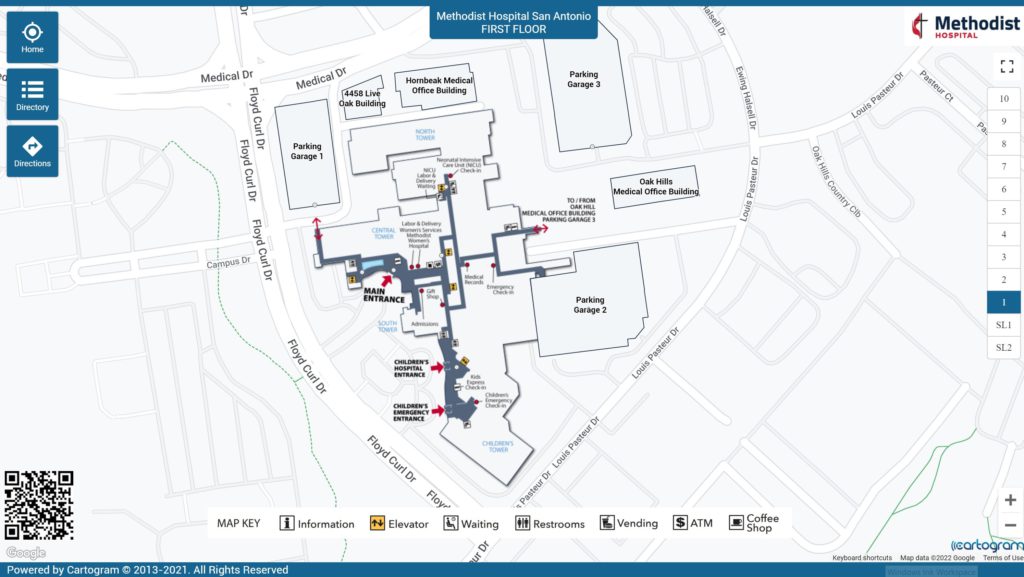
Cartogram’s Interactive Map for Methodist Hospital (San Antonio)